 |
Haverford Heritage Trail |
Directions from Previous Site: Continue along Parkview Road using sidewalk downhill (look for white house (Site 22) off to the right on the way down) to corner with Darby Creek Road, near Marple Road.
Physical Address: Marple Rd. and Darby Creek Rd.
GPS Coordinates: 39.98985, -75.34131
Parking: Lowest lot by Southbrook Trail and Dog Park
Ownership: Varies
Arcadia Book Page: No
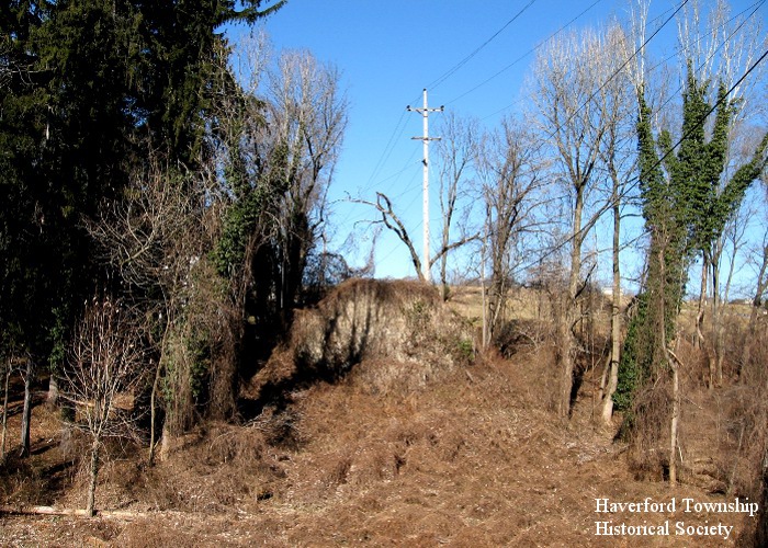
Description and History: In the golden age of railroading, a single-track railroad line called the Philadelphia and Delaware County Railroad was built between 1893 to 1895. It branched off from existing railroad tracks in the Fernwood section of Upper Darby and ended in rural Newtown Square (just west of present-day PA252), covering 10 miles. Passenger and freight trains began running in 1894, and the line became part of the vast Pennsylvania Railroad (PRR) system. Soon 7 passenger trains daily were serving 11 stations and flagstops in the rural communities along the route, but business levels were low and by 1908 the passenger service had ended. The line eventually became known as the PRR Newtown Square Branch, and continued to host short freight trains serving local customers. Diesel locomotives eclipsed steam engines in 1951. The branch was cut back in 1963 to just past Grassland (West Eagle Road in what is now called Oakmont), beyond which the many spindly bridges and trestles were deteriorating. The last train ran over the shortened line in 1981. Today, standing at the intersection of Parkview Drive and Darby Creek Road, one can look back to the left of Parkview Drive and discern a concrete bridge abutment with a utility line pole atop it (shown above). Just beyond it there was once a small passenger shelter called Brookthorpe Station. If one then turns while visually following the utility lines overhead and back aross the valley, one can spot the other abutment just across Marple Road, all but hidden behind pine trees and other foliage. A 457 foot long railroad trestle, 48 feet tall with intermediate pier supports, once spanned this distance. (More old railroad bridge supports can be seen by walking to the end of the Blue Route Trail within Haverford Reserve, where the railroad crossed Darby Creek into Marple Township.)
|
|
|
|